STEVE JACKOWSKI

fr.stevejackowski.com (site en Français)

  • Life & Work
  • Novels
    • The Swimmer
    • The Misogynist
    • The 15th Juror
    • The Shadow of God
    • The Silicon Lathe
    • L'Ombre de Dieu
    • Ethics
  • Blog
    • Electric Vehicles (EVs)
    • France
    • Personal
    • Sports
    • Startups
    • Work in Progress
    • Writing
  • Reviews
    • The Misogynist
    • The Shadow of God
    • The Silicon Lathe
  • Picture Gallery
  • Contact
  • Work in Progress

Four 4s - a Problem that will take you a while to Solve

11/17/2016

0 Comments

 
Picture
by Steve Jackowski

​I like to solve problems.  I also appreciate the instant gratification I get in solving Sudoku, KenKen, Minesweeper, or even FreeCell games as fast as I can.  The faster the better.

During my career, my teams and I were often faced with problems that couldn't be solved in minutes, hours, or even days.  We used systematic methods which required laying out multiple approaches to get to as many possible answers as possible.  Collaboration usually helped. Persistence helped.  But often we needed to walk away for a while and let our subconscious do the work; the answers arriving at odd times, like while taking a shower. 

I must admit that I worry about our problem solving abilities.  It seems like almost everything we do today is about faster and faster.  If we can't get gratification in a matter of minutes, we move on to something else.  Our attention spans are getting shorter.  Computers and our intelligent portable devices make this easier and easier.  I wonder if these addictions will lead us away from the sustained efforts needed to solve real world problems.  

In thinking about this, I remembered the first sustained problem-solving effort I faced.  I was 16.   My high school Calculus teacher presented a challenge to the class.  The first person to solve it would receive bonus points which could lead to the ever-sought-after A+.  He had discovered the problem in that month's issue of Scientific American.  It sounded simple enough:

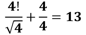
Create all the number from 1 to 100 using exactly four 4s.  

I dove right in, even before class was over and several numbers fell out quickly: 

1 = (4+4)/(4+4)
2 = (4*4)/(4+4)
3 = (4+4+4)/4
etc...

​But it didn't take long before I got stuck.  I decided to keep moving on, skipping those that I couldn't get quickly.   Once I realized I could use 4! (4*3*2*1 = 24), many more fell out.  But I got really stuck on several.  Days passed (I worked on this in my spare time) and one or two would fall out, then I'd be stuck again.  Skip the next two paragraphs of this post if you don't want any more hints.

Ultimately, I understood that to solve the harder ones I needed to create tools - combinations of 4s (e.g. 4/.4 = 10) that I could use in other expressions ( e.g. (4/.4)*sqrt(4)+4 = 24 - note that I used 'sqrt' here because I couldn't easily add the square root symbol in this post).  

The key was to think about other representations of 4, like factorial or square root, and then combine that with other representations to create numbers I could use to multiply, divide, add, or perform other operations with. It was a week or more before I had the tool building realization and then it took longer to build all the tools I needed.  When I got really stuck it was usually because I needed to create a new tool.  

Skip to here.

All told, it took me about 3 weeks.  I was pretty proud of the fact that I was the first in the class to come up with a solution and my Calculus teacher admitted that he hadn't solved it yet.  By the end of the term, as it turned out, no one else in all of his classes had solved it either.  I'm not saying it to brag, I'm just laying down the challenge.  Granted I've given you some hints that took me a while to get, but I'd be curious to see how long it takes you. 

Since I haven't looked at this problem in decades (and I didn't keep the solution anywhere), I'm going to start on it myself.

If you get really stuck, contact me via the website and I'll give you more hints or some additional tools.  Have fun!


0 Comments

Gorliz and the Lighthouse at the End of the World

11/5/2016

0 Comments

 
PictureThe village of Gorliz from the trail above. Note the river and harbor on the far end of the beach
When we finished our visit to San Juan de Gaztelugatxe​, we were a bit tired from the climb back up the 600 foot cliff.  But it was still early in the day and the late October weather was gorgeous with temperatures in the upper 70s.  We weren't sure whether we were up for another hike or just wanted to kick back on the edge of the water in one of the many seaside towns on the Spanish Basque Coast.

The coastline here is rugged.  It reminds me a bit of Big Sur with its imposing cliffs, precipitous drops to the sea,  rocks formations and small islands, and spectacular views.  The big difference is the rivers.  There's lots of water here and rivers rush from the Pyrenees to the ocean carving wide fertile valleys and creating coves and harbors with beautiful sandy beaches.  The beaches and harbors are protected by the huge cliffs to the east and west (remember this part of the coast of Spain faces north).  

PictureThe beach at Gorliz - deserted!
Jean-Luc and Elaine pulled out a guidebook for hikes in the Basque region and one caught my eye - a hike to the Lighthouse at the End of the World.  As it turned out, Jean-Luc and Elaine had done the hike so they were somewhat familiar with the area.  We set off on a scenic 25-minute drive to Gorliz where the trail began.  As we neared Gorliz, Elaine remembered the initial climb out of Gorliz towards the lighthouse, and after the morning's climb, suggested we might want to  see if we could get closer to the lighthouse to make it an easier hike.  She suggested a service road a service road they'd crossed the previous time and thought that we might be able to drive part way up.  Unfortunately, the road was closed to non-service vehicles, so we made our way to a cafe overlooking the beach at Gorliz to discuss our options.   

The beach was impressive - long, and completely deserted, aside from a few naturistes on the east end below the cafe's terrace.  

The village of Gorliz has about 5,000 permanent residents.  It's effectively a suburb of Bilbao and is the last stop on Bilbao's underground metro line.  The bay and beach were formed by the Plentzia River on the west end.  There's a protected harbor entrance at the mouth of the river. The large building on the beach path (as seen in the picture at the top of this post), is not a Casino as you might imagine, it's the hospital.  In the 1920s, Gorliz was the first place on the Basque coast to set up a salt-water spa for health treatments.  Now these are found in many of the towns and villages dotting the coast.  Karen and Elaine frequently go to the Thalassotherapy Spas in Hendaye and Saint-Jean-de-Luz.

Re-energized after their coffees, Elaine, Jean-Luc, and Karen thought we might give the hike a try after all.  

The climb up the trail from the east end of the beach was more challenging than expected but afforded us impressive views of Gorlitz, its beach, and the Plentzia River.  With the rising temperatures and the late October sun, we were grateful for the shade as we ascended the forested trail.  As we rounded the corner above the edge of the bay, the views to the west were breathtaking.  We kept thinking the trail would flatten out but it kept climbing.  

Picture
Looking west from what we hoped was the highest point.
Picture
Wild crocus along the way
Picture
Jean-Luc, Elaine, and Karen heading down to the trail you see below before heading up again.
Picture
Don't Fall! (Taken from the thin trail in the picture above.)
When the trail started to descend, we thought we had reached the highest point.  But no.  We had to go down a couple hundred feet, then climb a few hundred feet up the next hill.  That one had no trees and no shade.  We seriously discussed turning back.  But the lighthouse called.

We passed fields of wild crocus, and made our way up to the next highest point where we finally saw the Lighthouse at the End of the World.   
​
Picture
The Lighthouse at the End of the World
We followed the trail down to the access road which led to the lighthouse.  

The lighthouse itself wasn't particularly spectacular.  And while the views to the west were breathtaking, there was no way to see to the east - the part of the cliff that would have afforded that view  was overgrown with plants.  I must admit to being disappointed.  I also thought that it didn't live up to its 'end of the world' billing. 

There were also pictures and maps of the area marking additional hiking trails and describing the lighthouse's and the area's history.  

The trail starts again behind the lighthouse and climbs another hundred feet or so, passing bunkers and underground galleries complete with cannons built by Franco after the Spanish Civil war in anticipation of an invasion by the allies during WWII.  The trail then winds through scenic hills and valleys back to Gorliz.  

At this point, though, we were a bit tired.  Having climbed the cliffs of San Juan de Gaztelugatxe earlier and adding another thousand vertical feet here, we decided to take the shady service road back to Gorliz as the sun was setting.  

An hour and a half later we were home and got cleaned up for a romantic dinner at one of our local favorites, Tantina de la Playa in Bidart.  

If you decide to try the trail to the Lighthouse at the End of the World, set your expectations low for the lighthouse itself.  As for the rest of the hike, it's definitely worth it: incomparable views, some interesting history, and a somewhat challenging 6.4 km (4 mile), 300 meter (1000 foot) vertical loop.  And if it's summer or a warm fall day, don't forget to enjoy the beach and crystal clear waters of the Bay of Plentzia in Gorliz.
0 Comments

San Juan de Gaztelugatxe

11/3/2016

2 Comments

 
PictureGaztelugatze from the trail down
We'd had a couple of days of light rain in the Pays Basque region of France, but the forecast was for fair weather with temperatures rising into the upper 70s.  A perfect day for a bit of exploring on the Spanish Basque coast.  

We had originally planned to do the seven or eight mile hike near Itxaspe to see the spectacular Flysch (wildly twisted rock) formations in the cliffs along with caves, deserted beaches, and possibly some interesting surf spots.  Unfortunately, after mentioning this plan to some friends over lunch, we were informed that the cast and crew of Game of Thrones had taken over this stretch of coastline for the next week.  They had also recruited hundreds of extras for the shoots - but you had to be big, tall, hairy and ugly.  Clearly I didn't fit the bill.

Our next choice was San Juan de Gaztelugatxe, a medieval Hermitage built in the ninth century by the Knights Templar on a tiny island just off the Basque coast.  It is connected to the mainland by what our friend Elaine calls 'the great wall of China'.   

We awoke to light rain, but trusting the weather forecast (a crazy thing to do in the Pays Basque), we picked up Elaine and her significant-other, Jean-Luc, and headed into Spain.  Half an hour into our drive, the skies cleared.  It was going to be a fine day.

To get to San Juan de Gaztelugatxe, we took the A-8 towards Bilbao - about 90 minutes away, then headed north to the coast passing through the beach resort town of Bakio.  We drove past the entrance to the parking area, thinking there might be another trail down from further up the road, and quickly discovered that the road was closed because the cliffs had fallen in.  We had originally thought that after this hike, we might continue up the road to Bermeo, one of the largest Basque ports, but that wasn't going to be possible.  Also, any alternative trails were long gone with the slides.  

We parked in the mostly deserted parking lot and made our way to the trail noticing that in spite of the fine weather in late October, the nearby restaurants were closed.  Fortunately, we'd brought a picnic lunch which we planned to eat once we reached the Hermitage.  

PictureJean-Luc, Karen, and Elaine smiling on the way down.
The sign on the trail indicated it was only about 1.5km (about half a mile) to the Hermitage.  I found this hard to believe because we were at least 600 vertical feet above the ocean, and we had to then climb an additional 300 feet up to the Hermitage.  

We started down and discovered that the trail was wide but quite steep.  ​No one was looking forward to the climb back up.

Nearing the bottom, we crossed a service road and shortly thereafter came to the wall/bridge that leads to the island.  The coastline to the east and to the west (remember, the Spanish coastline here faces north) is spectacular with small islands, imposing cliffs and numerous 'natural bridges'.  The 'wall' is even more impressive. Between the mainland and the island, at high tide, water passes through large arches in the bridge. Surprisingly, there are steps down the side that lead to these arches if you want a more impressive view.  Fortunately for us, the tide was high and there were a few workers cleaning the rough stones on the steps down.  With the heavy surf crashing below, we weren't tempted.  

Instead, we began the climb up the 237 steps to the Hermitage.  
Picture
Coastline looking east.
Picture
Coastline with 'bridge' looking west.
PictureThe wall and steps looking down from near the top of the island.

It's a challenging climb up the steps and ramps, but there are handrails and numerous flat places to stop and take pictures (or to catch your breath).  

Arriving at the top, you round the main building and you see the huge wooden doors to the Hermitage, along with a rope that leads up to the bell tower.  

Legend has it that once you've made the trek, you should ring the bell three times and make a wish.  

Although there aren't many people who live nearby on the mainland across from the island, I have to believe that the neighbors get pretty tired of the ringing bell, especially during the summer tourist season.

We toured the top of the island looking for a good place to picnic and finally settled on a sun-sheltered structure on the side of the church.  Unfortunately, the church doors were locked, so we were forced to peek through the crack in the doors to see the interior.  
​  

PictureInside the church - thanks to Telle for the photo.
Gaztelugatxe comes from two Basque words - gaztelu which means castle or fortress, and gatxe which means tremendously difficult.  

Historians aren't clear exactly when the Hermitage was built. However, there are nearby graves dating from the 9th century and historical records showing its existence in the 10th century.  It was apparently built by the Knights Templar and became a monastery during first part of the 11th century.

Interestingly, this small island and its Hermitage were the site of several strategic battles.  Its access was challenging so the site was easily defensible and over the course of its history, several notable figures made successful 'last' stands here.

Seeing its strategic importance, Sir Francis Drake successfully attacked and conquered the site in 1593.  Since then, the site has changed hands numerous times.  

The history is interesting. The short though challenging walk down the cliffs, up to the Hermitage, then down from the Hermitage and back up the cliffs can be exhausting.  Still, the views are worth the effort.  If you're in the area, it's definitely worth the short detour from Bilbao to see San Juan de Gaztelugatxe.  

​By the way, apparently the cast and crew of Game of Thrones will also be using San Juan de Gaztelugatxe in episodes this next season.  Watch for it!

Picture
Plaque on the side of the Hermitage - built for John the Baptist.
2 Comments
    Picture

    Steve Jackowski

    Writer, extreme sports enthusiast, serial entrepreneur, technologist.

     
    Check out my latest novel!
    Picture

    Categories

    All
    Electric Vehicles (EVs)
    France
    Personal
    Sports
    Startups
    Work In Progress
    Writing

    RSS Feed

    Archives

    September 2022
    June 2022
    October 2021
    June 2021
    October 2020
    September 2020
    May 2020
    December 2019
    November 2019
    September 2019
    August 2019
    July 2019
    June 2019
    May 2019
    October 2018
    September 2018
    June 2018
    January 2018
    November 2017
    September 2017
    August 2017
    June 2017
    April 2017
    March 2017
    January 2017
    December 2016
    November 2016
    October 2016
    June 2016
    April 2016
    March 2016
    December 2015
    July 2015
    June 2015
    May 2015
    March 2015
    February 2015
    January 2015
    December 2014
    November 2014
    October 2014
    September 2014
    August 2014
    July 2014
    June 2014
    May 2014
    April 2014
    March 2014
    February 2014
    January 2014
    December 2013
    November 2013
    October 2013
    September 2013


Proudly powered by Weebly

BACK TO TOP

Plain & Simple Web Design © 2013